Session 2: Assignment Answers#
Apply session 2 material to create a remote model-based Tornado and local dataset-based Tornado with the given information and get hazard values from created hazards
Agenda
1. Create a model-based Tornado (Remote)
2. Create a dataset-based Tornado (Local)
Please follow the instruction at each cell.
1. Create a model-based Tornado (Remote)#
Using the data from section 2.1.2, slightly alter the values of the Centerville tornado and obtain a new set of parameters that differ from the previously seen examples.
Tornado model definition:
Tornado Model: MeanWidthTornado
EF Rating: EF3
Start point of path:
Latitude:
Longitude:
End point of path:
Latitude:
Longitude:
Wind speed method: 1
number of simulation: 1
random seed: 2023
After you have obtained them, proceed as shown during the session.
# Import modules
from pyincore import HazardService, IncoreClient
import json
# Connect to IN-CORE serivce by creating IncoreClient
client = IncoreClient()

# Create the HazardService object
hazardsvc = HazardService(client)
Connection successful to IN-CORE services. pyIncore version detected: 1.15.1
# TODO: create a JSON (dictionary) definition of tornado model as given above
my_tornado_model = {
  "name": "Centerville Model Tornado (modified)",
  "description": "Centerville mean width tornado hazard",
  "tornadoType": "model",
  "tornadoModel" : "MeanWidthTornado",
      "tornadoParameters" : {
      "efRating" : "EF3",
      "startLatitude" : "35.215",
      "startLongitude" : "-97.524",
      "randomSeed" : "2023",
      "endLatitude" : [35.253],
      "endLongitude" : [-97.432],
      "windSpeedMethod" : "1",
      "numSimulations" : "1"
    }
}
tornado_model_json = json.dumps(my_tornado_model, indent=4)
# TODO: create a tornado using the hazard service
model_response = hazardsvc.create_tornado_scenario(tornado_model_json)
print(json.dumps(model_response, indent=4, sort_keys=False))
{
    "tornadoType": "model",
    "id": "65ccfa2ad61b8f0bb597b153",
    "name": "Centerville Model Tornado (modified)",
    "description": "Centerville mean width tornado hazard",
    "creator": "cwang138",
    "owner": "cwang138",
    "threshold": null,
    "thresholdUnit": "mph",
    "spaces": [
        "cwang138"
    ],
    "date": "2024-02-14T17:36:41+0000",
    "tornadoModel": "MeanWidthTornado",
    "tornadoParameters": {
        "efRating": "EF3",
        "maxWindSpeed": 250.0,
        "startLatitude": 35.215,
        "startLongitude": -97.524,
        "randomSeed": 2023,
        "windSpeedMethod": 1,
        "numSimulations": 1,
        "endLatitude": [
            35.253
        ],
        "endLongitude": [
            -97.432
        ]
    },
    "tornadoWidth": [
        413.78265910931174
    ],
    "efBoxes": [
        {
            "efBoxWidths": [
                0.0006292397330261612,
                0.0010052942480299617,
                0.0014930481239259802,
                0.0018616560148702996
            ]
        }
    ],
    "hazardDatasets": [
        {
            "datasetId": "65ccfa29b63a91456d2830f0",
            "demandType": "wind",
            "demandUnits": "mph",
            "threshold": null
        }
    ]
}
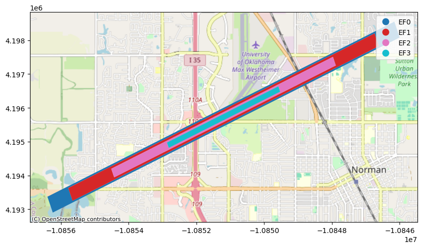
# TODO: acquire hazard id you created and visualize
tornado_model_id = model_response['id']
from pyincore_viz.geoutil import GeoUtil as viz
viz.plot_tornado(tornado_model_id, client, basemap=True)
# TODO: Getting and printing hazard value from your tornado
points = [
    {
        "demands": ["wind"],
        "units": ["mph"],
        "loc": "35.215, -97.521"
    },
    {
        "demands": ["wind"],
        "units": ["mph"],
        "loc": "35.233, -97.479"
    }
]

tornado_model_vals = hazardsvc.post_tornado_hazard_values(tornado_model_id, points)
print(json.dumps(tornado_model_vals, indent=4, sort_keys=False))
[
    {
        "hazardValues": [
            82.54130976754479
        ],
        "demands": [
            "Wind"
        ],
        "units": [
            "mph"
        ],
        "loc": "35.215, -97.521"
    },
    {
        "hazardValues": [
            139.8882517057174
        ],
        "demands": [
            "Wind"
        ],
        "units": [
            "mph"
        ],
        "loc": "35.233, -97.479"
    }
]
2. Create a dataset-based Tornado (Local)#
Now, using the dataset-based tornado definition seen in section 3.1.1, define a new local tornado hazard and get values for the same location with and without a seed parameter.
Proceed as in the prior exercise.
# Import modules
from pyincore import Tornado
import os
# TODO: indicate the path of the tornado dataset files
dir = "data/hazard/tornado/"
# TODO: create the tornado object with definition
tornado = Tornado.from_json_file(os.path.join(dir, "tornado_dataset.json"))

# TODO: attach the shapefile representing the tornado
tornado.hazardDatasets[0].from_file((os.path.join(dir, "joplin_path_wgs84.shp")),
                                    data_type="incore:tornadoWindfield")
# TODO: Getting and printing hazard value from your tornado for specific seed value
payload = [
    {
        "demands": ["wind"],
        "units": ["mph"],
        "loc": "-94.37, 37.04"
    }
]

# get values
values = tornado.read_hazard_values(payload, seed=1234) # removing the seed will give random values
print(values)
[{'demands': ['wind'], 'units': ['mph'], 'loc': '-94.37, 37.04', 'hazardValues': [None]}]
# TODO: Getting and printing hazard values from your tornado for a random seed value
payload = [
    {
        "demands": ["wind"],
        "units": ["mph"],
        "loc": "-94.37, 37.04"
    }
]

# get values
values = tornado.read_hazard_values(payload) # removing the seed will give random values
print(values)
[{'demands': ['wind'], 'units': ['mph'], 'loc': '-94.37, 37.04', 'hazardValues': [None]}]
# TODO: Visualize the tornado using GeoDataFrame.explore(), see section 3.2.1 for getting the geodataframe
tornado_gdf = tornado.hazardDatasets[0].dataset.get_dataframe_from_shapefile()
tornado_gdf.explore()